MetService - Te Ratonga Tirorangi
  • National
  • Towns & Cities
  • Rural
  • Marine
  • Mountains & Parks
  • Maps & Radar
  • Warnings
  • News
  • About MetService
  • Weather for business
  • Blog
  • Contact Us
  • National
  • Towns & Cities
  • Rural
  • Marine
  • Mountains & Parks
  • Maps & Radar
  • Warnings
  • News
  • About MetService
  • Weather for business
  • Blog
  • Contact Us

For best results when printing, resize your browser window to single column view before selecting print.
Forecasts and warnings may be updated at any time - always check metservice.com for the latest information.
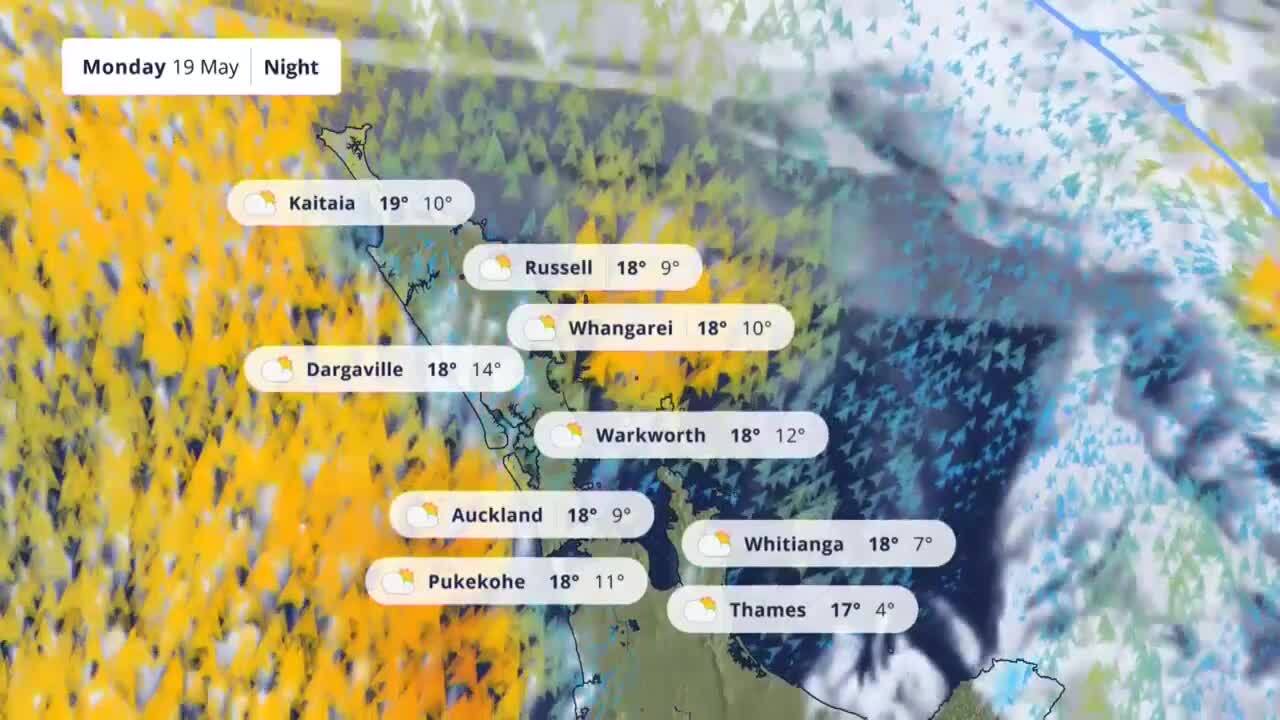
  • Next 48 Hours
  • 7 Days
  • Extended
  • Water Activities
  • Nearby Forecasts
  • Past Weather
  • No warnings in place for Auckland
View all severe weather 

Current Conditions

Wind: In the last 10mins
Rain, humidity, and pressure: Latest hourly observation

Auckland Aero Automatic Weather Station (93110)
16.8°

Feels like 17°

  • 18°
  • 9°
  • 0mm
  • 35km/h SW
Clothing2 layers
0 windproof
WindFresh 35km/h SW
Gusts 50km/h
Harbour BridgeFresh 39km/h SW
Gusts 56km/h
Rainfall0.0mm
Humidity64%
Pressure1017hPa
Falling
Observations by MetService

Auckland Rain Radar

Animates Pet Forecast

Footpath Temperature

Low risk all day
Pawfect weather for a stroll!

Heat Stress

Low risk all day
Low heat stress today, pets still need water and shade.

Pawfect Time to Walk

Good all day
It is better to walk in the morning or evening if you can.

We make happy happen

Laundry & Pollen

Laundry Drying Time

Morning: 1 - 3 hrs
Afternoon: 1 - 3 hrs

Pollen Forecast

Low
Outdoor fungi releasing spores. Cypress and cedar releasing pollen but heavy pollen grains mean it doesn't travel far.

Today

19 May

18°
9°
  • Overnight
  • Morning
  • Afternoon
  • Evening

Tue

20 May

16°
8°
  • Overnight
  • Morning
  • Afternoon
  • Evening

Today 19 May

sunrise 7:15am

sunset 5:20pm

Partly cloudy, with the chance of a shower near the west coast. Fresh southerlies, easing this afternoon.

Issued: 11:47am Mon 19 May

FIRE SEASON

Open except Public Conservation Estate

Other than public conservation land, permits are not required today.

FIRE DANGER

Low

You should be able to manage the risks of wildfire now.

Data provided by

Information

High: Forecast for the calendar day. Usually occurs in the afternoon.

Low: Forecast between noon on the calendar day and noon the following day. Usually occurs around dawn.

Forecast times: Overnight: Midnight - 6am, Morning: 6am - Noon, Afternoon: Noon - 6pm, Evening: 6pm - Midnight.

Forecast Icons Key

Fire Season

Open: Fires may be lit in open air, without restriction.
Restricted: Lighting a fire is riskier than usual. A fire permit is required for most fire types
Prohibited: Lighting fires in the open air is not permitted. Existing fire permits are suspended, though fire permits may still be granted in exceptional circumstances.

All fires are restricted on Department of Conservation land. Check if you need a permit at FENZ

Fire Danger

Extreme: Any outbreak of fire is extremely serious! All fires are potentially serious and will easily become uncontrollable, unpredictable and fast moving. These fires are very difficult to fight and may become very dangerous and often last for several days.
Very high: Outbreak of fire is very serious! Fires will start easily and will spread rapidly and burn intensely right after ignition. Small fires can quickly become large fires and show extreme fire behaviour. These fires can be difficult to control and will often become much larger and longer-lasting fires.
High: Outbreak of fire is serious! Fires can start easily and control becomes increasingly more difficult the longer the fire is left.
Moderate: Control of fires is reasonably easy. Fires are not likely to become serious and are often easy to control if attended to quickly.
Low: Wildfires are unlikely. Ignition may take place near large and prolonged heat sources but the resulting fires generally do not spread much. Control of fires is generally easy.

Hourly Observations and Forecast

Mon 19 May
Tue 20 May
Wed 21 May

1am

2am

3am

4am

5am

6am

7am

8am

9am

10am

11am

12pm

1pm

2pm

3pm

4pm

5pm

6pm

7pm

8pm

9pm

10pm

11pm

12am

1am

2am

3am

4am

5am

6am

7am

8am

9am

10am

11am

12pm

1pm

2pm

3pm

4pm

5pm

6pm

7pm

8pm

9pm

10pm

11pm

12am

1am

2am

3am

4am

5am

6am

7am

8am

9am

10am

11am

Rainfall (mm/h)

1.0

0

0

0

0

0

0

0

0

0

0

0

0

0

0

0

0

0

0

0

0

0

0

0

0

0

0

0

0

0

0

0

0

0

0

0

0

0

0

0

0

0

0

0

0

0

0

0

0

0

0

0

0

0

0

0

0

0

0

Temperature (°C)

Avg wind speed (not gusts) in km/h

S

15

S

17

S

15

S

15

S

20

SW

22

SW

20

S

19

SW

28

SW

31

SW

37

SW

36

SW

35

SW

35

SW

32

SW

31

SW

30

SW

26

SW

24

SW

24

SW

24

SW

24

S

22

S

20

S

19

S

19

S

17

S

17

S

15

S

11

S

11

S

11

S

11

S

15

S

17

S

20

S

20

S

20

S

20

S

19

S

17

SW

13

S

11

S

9

S

9

S

9

SE

7

SE

7

SE

7

SE

7

SE

6

SE

6

SE

6

SE

6

SE

4

SE

6

SE

6

SE

6

SE

7

Observed
Forecast
Keys

    Total rainfall so far today: 1.0 mm. Total rainfall forecast for today: 1.0 mm

    Wind (km/h)

    • Calm:
      0
    • Light Winds:
      1 - 14
    • Moderate:
      15 - 29
    • Fresh:
      30 - 39
    • Strong:
      40 - 62
    • Gale:
      63 - 89
    • Severe Gale:
      > 89

    Rain (mm/h)

    • Light:
      0.2 - 2.0
    • Moderate:
      2.1 - 6.0
    • Heavy:
      6.1 - 25
    • Torrential:
      > 25

    The hourly model data shown can differ from the written forecast and icons, which are produced by MetService meteorologists and take into account model data along with many other data sources. If they differ significantly, please use the text forecasts.

    Forecast data is specifically generated for Auckland Aero Automatic Weather Station (93110). Rainfall shown is for the sum up to the hour. Wind speed, wind direction and temperature are the observed or forecast values at the given hour.

    Commute Forecast

    Transit
    Cycling
    Walking
    Driving

    This afternoon

    3pm
    Very windy 32km/h SW, gusts 46km/h
    4pm
    Very windy 31km/h SW, gusts 46km/h
    5pm
    Very windy 30km/h SW, gusts 43km/h
    6pm
    Pretty good

    Tomorrow morning

    6am
    Lovely
    7am
    Chilly 9°
    8am
    Lovely
    9am
    Lovely

    Auckland Traffic Cameras

    • Dannemora Maps & Radar
    • Manukau Tides Overview
    • Video Forecast
    • Sun & Moon
    • Current Extremes
    • Yesterday's Extremes
    • Weather News

    Dannemora Maps & Radar

    View all maps & radar

    3 day rain forecast

    Tasman surface pressure

    Your weather

    Rain radar

    Manukau Tides Overview

    LOCATIONHIGHLOWHIGHLOWHIGH
    Onehunga02:313.6m08:521.3m14:583.4m21:111.3m-
    Raglan02:102.8m08:230.9m14:372.7m20:400.9m-
    Muriwai Beach01:51 08:22 14:18 20:41 -
    Pouto Point02:272.9m08:451.0m14:542.7m21:011.0m-
    Maraetai-05:25 11:38 17:34 -
    Auckland-05:401.0m11:532.9m17:491.0m-

    Video Forecast

    See more video forecasts
    Upper North Island on Monday
    Upper North Island on Monday
    Video Player is loading.
    Current Time 0:00
    /
    Duration 0:21
    Loaded: 47.16%
    0:00
    Stream Type LIVE
    Remaining Time -0:21
     
    1x
      • Chapters
      • descriptions off, selected
      • subtitles settings, opens subtitles settings dialog
      • subtitles off, selected
      • en (Main), selected

      This is a modal window.

      Beginning of dialog window. Escape will cancel and close the window.

      Text
      Text Background
      Caption Area Background
      Font Size
      Text Edge Style
      Font Family

      End of dialog window.

      This is a modal window. This modal can be closed by pressing the Escape key or activating the close button.

      Sun & Moon

      Sun & moon hours

      • Sunrise

        7:15am

      • Sunset

        5:20pm

      • Moonrise

        10:47pm

      • Moonset

        12:35pm

      Moon phases

      • Last quarter

        21 May

      • New moon

        27 May

      • First quarter

        3 Jun

      • Full moon

        11 Jun

      Current Extremes

      Highest

      18.5°

      Whakatāne

      Lowest

      5.1°

      Twizel

      Windiest

      67km/h

      Stewart Is.

      Wettest

      5.0mm

      Castlepoint

      Yesterday's Extremes

      Hottest
      Coldest
      Wettest
      Windiest
      RankLocationMax TempPrevUp/down
      1Napier Airport21.8°7+6
      2Napier21.2°1-1
      3Hastings21.1°2-1
      4Kaitaia Hospital21.0°27+23
      5Waikawau Bay21.0°14+9
      19Auckland Airport19.8°21+2

      Rank of the locations with the highest air temperature recorded yesterday. Prev is the previous day's rank for the location. The arrow shows if the current rank is higher or lower than that for the previous day. Max of 5 locations plus current town/city shown.

      Weather News

      Winter comes knocking after a wet weekend
      Issued: 11:43am Mon, 19 May
      • A soggy start gives way to crisp, clear conditions across most of Aotearoa.
      • Cold southerlies sweep in behind the weekends rain, dropping temperatures into the low single digits.
      • Frosts are expected for many from Tuesday, particularly ...

      North Island

      Northland
      • Dargaville
      • Kaikohe
      • Kaitaia
      • Kaitaia Airport
      • Kerikeri
      • Paihia
      • Russell
      • Whangārei
      Auckland
      • Auckland Central
      • Hunua
      • Kumeu
      • Manukau
      • North Shore
      • Pukekohe
      • Pōkeno
      • Tuakau
      • Waiheke Island
      • Waitakere
      • Warkworth
      Waikato
      • Cambridge
      • Hamilton
      • Huntly
      • Matamata
      • Morrinsville
      • Ngāruawāhia
      • Paeroa
      • Putāruru
      • Raglan
      • Te Aroha
      • Te Awamutu
      • Tokoroa
      Waitomo
      • Piopio
      • Te Kuiti
      • Waitomo
      Coromandel
      • Thames
      • Waihi
      • Waikawau Bay
      • Whangamatā
      • Whitianga
      Rotorua
      • Ngongotahā
      • Rotorua
      Bay of Plenty
      • Katikati
      • Kawerau
      • Mount Maunganui
      • Opotiki
      • Papamoa
      • Tauranga
      • Te Puke
      • Whakatāne
      • Ōhope
      • Ōmokoroa
      Taupō
      • Taupō
      • Taupō Airport
      • Tūrangi
      Gisborne
      • Gisborne
      • Ruatoria
      Hawke's Bay
      • Eastern Rangitaiki
      • Hastings
      • Havelock North
      • Mahia
      • Napier
      • Napier Airport
      • Waipukurau
      • Wairoa
      Taranaki
      • Eltham
      • Hāwera
      • Inglewood
      • New Plymouth
      • New Plymouth Airport
      • Opunake
      • Stratford
      Taumarunui
      • Taumarunui
      Taihape
      • Ohakune
      • Waiouru
      Whanganui
      • Whanganui
      • Whanganui Airport
      Manawatu
      • Feilding
      • Hunterville
      • Ohakea
      • Palmerston North
      • Palmerston North Airport
      Wairarapa
      • Carterton
      • Castlepoint
      • Dannevirke
      • Featherston
      • Martinborough
      • Masterton
      Kapiti-Horowhenua
      • Levin
      • Paraparaumu
      • Te Horo
      • Waikanae
      • Ōtaki
      Wellington
      • Judgeford
      • Lower Hutt
      • Lyall Bay
      • Ohariu Valley
      • Porirua
      • Upper Hutt
      • Wainuiomata
      • Wellington Central

      South Island

      Marlborough
      • Blenheim
      • Kaikōura
      • Kaikōura Airport
      • Picton
      Nelson
      • Golden Bay
      • Motueka
      • Murchison
      • Nelson
      • Richmond
      • St Arnaud
      • Takaka
      Buller
      • Reefton
      • Westport
      Grey
      • Greymouth
      Westland
      • Franz Josef
      • Haast
      • Hokitika
      Canterbury Plains
      • Ashburton
      • Darfield
      • Kaiapoi
      • Methven
      • Pegasus
      • Rakaia
      • Temuka
      • Timaru
      • Waimate
      • Waipara
      Canterbury High Country
      • Culverden
      • Hanmer Springs
      • Mount Cook
      • Omarama
      • Twizel
      Christchurch
      • Banks Peninsula
      • Christchurch Central
      • Eastern Suburbs
      • Hilltop
      • Lincoln
      • Marshland
      • Port Hills
      • Prebbleton
      • Rolleston
      North Otago
      • Oamaru
      • Oamaru Airport
      Central Otago
      • Alexandra
      • Cromwell
      Dunedin
      • Dunedin
      • Leith Saddle
      • Middlemarch
      • Mosgiel
      • Port Chalmers
      • Waitati
      Clutha
      • Balclutha
      • Nugget Point
      Southern Lakes
      • Glenorchy
      • Lake Hayes
      • Queenstown
      • Wānaka
      Southland
      • Gore
      • Invercargill
      • Lumsden
      • Milford Sound
      • Stewart Island
      • Te Anau

      Get your everyday weather app!

      • Download on the App Store
      • Get it on Google Play
      • News
      • About
      • Products & Services
      • Contact
      • Careers
      • Legal Disclaimer

      This information is provided for your own personal non-commercial use in accordance with the MetService website terms and conditions.

      Copyright Meteorological Service of New Zealand Ltd. 2008-2025

      Version: 9.0.1